Krefeld -1960
Whipsnade -1967
Interesting. This was on their website anyway:
'En 1968, le parc zoologique de Montpellier fut le premier zoo européen à réussir la reproduction de guépards en captivité.'
Krefeld -1960
Whipsnade -1967
Interesting. This was on their website anyway:
'En 1968, le parc zoologique de Montpellier fut le premier zoo européen à réussir la reproduction de guépards en captivité.'
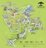
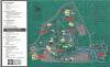
What are people's thoughts on cardinal orientation? I've noticed that zoos tend to orient their maps in all different directions with no clear pattern. Sometimes it annoys me a little if they aren't North-East-South-West oriented from top going clockwise as is the standard with most geographical maps I've seen, but I don't think it really makes much difference.
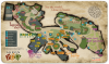
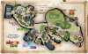
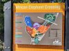
Zoo Map – Philadelphia Zoo
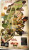
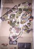
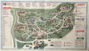
my home zoo's current map. i think it looks pretty good but kinda bland.
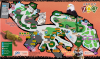
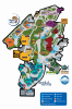
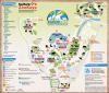
Great color scheme, easy to read animal icons, and overall very beautiful to look at. In all honesty, this is one of the best maps I've seen!Here is a map I made for a fantasy zoo exhibit based on Turkey. Took around a month of pretty solid work. Opinions? Not very effective for your average visitor given that some of the drawings are too small/bad to effectively depict an animal, especially when the visitor does not know of the animal, but I'm wondering more about the landscape/style. Thoughts?
Full map - Map of Turkish exhibit - ZooChat

Great color scheme, easy to read animal icons, and overall very beautiful to look at. In all honesty, this is one of the best maps I've seen!

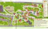
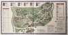
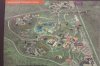
I agree. While it looks gorgeous it doesn't work that well when it comes to finding an animal or where you are.While not as bad as some on this thread, I feel like Pittsburgh Zoo’s map needs improvement. It doesn’t label any of the animals, and the website only includes a few. I had no clue they kept certain species (fossa, Pygmy hippo) and missed them, simply because I had no clue they were even there from the map. At least Atlanta’s says what animals they have. View attachment 672185


.jpg")
I agree. While it looks gorgeous it doesn't work that well when it comes to finding an animal or where you are.